


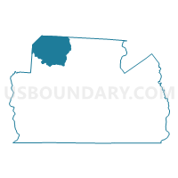
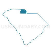
Bethany Voting District, York County, South Carolina
About
Outline

Summary
| Unique Area Identifier | 666969 |
| Name | Bethany Voting District |
| County | York County |
| State | South Carolina |
| Area (square miles) | 43.24 |
| Land Area (square miles) | 42.98 |
| Water Area (square miles) | 0.26 |
| % of Land Area | 99.39 |
| % of Water Area | 0.61 |
| Latitude of the Internal Point | 35.12144840 |
| Longtitude of the Internal Point | -81.31648930 |
Maps

Graphs
Select a template below for downloading or customizing gragh for Bethany Voting District, York County, South Carolina


Neighbors
Neighoring Voting District (by Name) Neighboring Voting District on the Map
- Voting District 04, Gaston County, NC
- Voting District 19, Gaston County, NC
- Voting District 22, Gaston County, NC
- Antioch and King's Creek Voting District, Cherokee County, SC
- Bowling Green Voting District, York County, SC
- Clover No. 2 Voting District, York County, SC
- Cotton Belt Voting District, York County, SC
- Filbert Voting District, York County, SC
- Voting District GROVER, Cleveland County, NC
- Voting District KM4, Cleveland County, NC
- Smyrna Voting District, York County, SC
Top 10 Neighboring County Subdivision (by Population) Neighboring County Subdivision on the Map
- Cleveland, Cleveland County, NC (98,078)
- Gastonia township, Gaston County, NC (85,249)
- Clover CCD, York County, SC (32,305)
- York CCD, York County, SC (24,213)
- Crowders Mountain township, Gaston County, NC (15,821)
- Blacksburg CCD, Cherokee County, SC (9,653)
Top 10 Neighboring Unified School District (by Population) Neighboring Unified School District on the Map
- Gaston County Schools, NC (206,086)
- Cleveland County Schools, NC (98,078)
- Cherokee County School District, SC (53,383)
- York School District 2, SC (34,368)
- York School District 1, SC (31,112)
Top 10 Neighboring State Legislative District Lower Chamber (by Population) Neighboring State Legislative District Lower Chamber on the Map
- State House District 109, NC (73,605)
- State House District 111, NC (68,632)
- State House District 47, SC (40,075)
- State House District 30, SC (34,013)
- State House District 29, SC (32,990)
Top 10 Neighboring State Legislative District Upper Chamber (by Population) Neighboring State Legislative District Upper Chamber on the Map
- State Senate District 43, NC (173,686)
- State Senate District 46, NC (165,888)
- State Senate District 15, SC (122,748)
- State Senate District 14, SC (98,937)
Top 10 Neighboring 111th Congressional District (by Population) Neighboring 111th Congressional District on the Map
- Congressional District 9, NC (852,377)
- Congressional District 5, SC (767,773)
- Congressional District 10, NC (689,468)
Top 10 Neighboring Census Tract (by Population) Neighboring Census Tract on the Map
- Census Tract 615.01, York County, SC (7,730)
- Census Tract 9506.02, Cleveland County, NC (6,014)
- Census Tract 9704.02, Cherokee County, SC (6,007)
- Census Tract 617.05, York County, SC (4,869)
- Census Tract 618.02, York County, SC (4,541)
- Census Tract 617.01, York County, SC (4,395)
- Census Tract 317.01, Gaston County, NC (3,670)